It is said that Marcel Proust preferred to read train timetables as he fell asleep. According to Alain de Botton:
The document was not consulted for practical advice; the departure time of the Saint-Lazare train was of no immediate importance to a man who found no reason to leave Paris in the last eight years of his life. Rather, this timetable was read and enjoyed as though it were a gripping novel about country life, because the mere names of provincial train stations provided Proust’s imagination with enough material to elaborate entire worlds, to picture domestic dramas in rural villages, shenanigans in local government, and life out in the fields. Proust argued that enjoyment of such wayward reading material was typical of a writer, someone who could be counted on to develop enthusiasms for things that were apparently out of line with great art.
While I have my doubts that Proust would have been enthusiastic about social media (it would take at least 80,000 Tweets to narrate In Search of Lost Time), I do think he would understand why I lately have been “reading Google Earth” before I fall asleep each night. Google Earth for the iPad is an opiate for the geo-curious. Some nights I spend in Yemen, others in Siberia. I spent one night re-tracing a day-long walk I took over ten years ago along the southern coastline of Easter Island – from Hanga Roa to Orongo to Ahu Vinapu and then cutting back through the barren hills that overlook the island’s airport and its weekly departures to Chile and Polynesia. I return to Caracas and Sao Paulo and spend hours exploring all the neighborhoods that I am forever told to never enter.

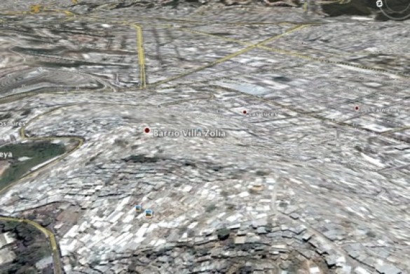
From the organic chaos of Caracas’ hillside Barrio Villa Zolia to the rectangular blocks of Los Carmenes.
Most nights, however, I spend right here in Mexico City, levitating from one neighborhood to the next, clicking on Wikipedia links as I go.

The view toward downtown Mexico City from Tacubaya in 1836.

The view toward downtown Mexico City from Tacubaya in 2011.
I am sure that Marcel Proust was not the only Frenchman who read train timetables as he fell asleep at the turn of the 20th century. As he himself claimed, “such wayward reading material was typical of a writer.” Today there are vast online communities of Google Earth users that share their imaginary explorations with one another. The official Google Earth Sightseer Newsletter is probably the best place to start. There is also an active community at The Earth Explorer. Some of the best blogs are Google LatLong, Google Earth Blog, and my personal favorite, Ogle Earth by Stefan Geens.
Geens writes with Proustian enthusiasm and curiosity. Last month he mapped the travels of Freya Stark’s 1968 Land Rover expedition from Kabul to Herat when Afghanistan was still a major segment of the infamous Hippie Trail of the 1960’s and 70’s. The result is an awe-inspiring piece of geographic storytelling; perhaps more rewarding than Stark’s own account.

Some of the major locations from Freya Stark’s “The Minaret of Djam.” Each location links to the relevant excerpt on Google Books, and often to other websites with more information and context.
Eventually, after an hour or so of exploration, my eyes grow heavy and I start to doze off. I drift in and out of consciousness, climbing up mountains to reach deserted minarets or following deep blue rivers along the vast expanse of Siberia or searching for mysterious bodies of water in Yemen’s arid moonscape. It is a wonderful, Proustian way to fall asleep.


Trackbacks/Pingbacks